Recommendatory Associated Protective Measures (APMs) are:
-
.1 An area to be avoided (ATBA) encompassing the reefs, shoals, and islets
that lie generally to the north-east of the GBR, between Palm and
Hydrographers Passage. Keeping transiting SOLAS ships clear of this area will mitigate the
risk of groundings and allow more time for intervention, in case of
developing situations (e.g. a ship suffering breakdown of its propulsion
machinery) (see appendix 3 of document MEPC 68/10/1 for further
information);
-
.2 Two 5 nautical mile wide two-way routes – one in Diamond Passage and the
other to the West of Holmes Reef in the south-west Coral Sea.
-
.1 The two-way route in Diamond Passage extends from approximately 25
nautical miles south of Diamond Passage through to approximately 35
nautical miles north of the passage.
-
.2 The two-way route West of Holmes Reef extends for 32.5 nautical
miles approximately north west of Holmes Reef and 20.5 nautical
miles approximately south west of Holmes Reef; and
-
.3 The proposed two-way routes aim to reduce the risks of collision
and grounding of ships by separating opposing streams of traffic,
whilst ensuring ships avoid the shoals, reef and islands that lie
close outside the two-way routes. The two-way routes also aim to
allow ships to follow well-defined lanes, thereby enhancing the
safety and efficiency of navigation through effective passage
planning. (see appendix 4 of document MEPC 68/10/1 for further
information).
The APMs are new ships' routeing systems under SOLAS regulation V/10 and are provided in full in
appendices 3 and 4 of document MEPC 68/10/1 and depicted in the chartlets below.
Description of the Two-Way Routes And Associated Chartlets in the Coral Sea
The ship routeing systems consist of two recommendatory two-way routes in the
south-west portion of the Coral Sea, each being five nautical miles wide.
Diamond Passage
The Diamond Passage two-way route starts approximately south east of South
Diamond Islet and extends on a bearing of 019-199 degrees for 24.5 nautical miles. It
then changes to a bearing of 008-188 degrees for 35 nautical miles.
From the two-way route's centreline, the closest distance to the 100 metre
bathymetric contour is approximately 6.9 nautical miles in both east and west
directions. This means that the passage width between those contours, at its narrowest,
is approximately 13.8 nautical miles.
West of Holmes Reef
The Holmes Reef two-way route commences west of Flora Reef and extends along
a bearing of 012-192 degrees for 20.5 nautical miles. The bearing changes to 040-220
degrees for 32.5 nautical miles. Holmes Reefs and Flora Reef are over 10 nautical miles
from the eastern limit of the two-way route.
Names, Numbers, Editions and Geodetic Datums of the Reference Charts
| Diamond Passage
|
|
|
|
|
|
|
|
|
| Names
|
Number
|
Edition
|
Datum
|
| Diamond Passage
|
AUS614
|
Ed 2
|
WGS84
|
| Willis Islets
|
AUS617 Pt 1
|
Ed 2
|
WGS84
|
| South West Islet to Magdelaine
Cays
|
AUS617 Pt 2
|
Ed 2
|
WGS84
|
| Mackay to Solomon Islands
|
AUS4621 (INT621)
|
Ed 4
|
WGS84
|
|
|
|
|
|
| West of Holmes Reef
|
|
|
|
| Names
|
Number
|
Edition
|
Datum
|
| Flinders Reefs
|
AUS615 Pt 1
|
Ed 2
|
WGS84
|
| Flora Reef and Holmes Reefs
|
AUS615 Pt 2
|
Ed 2
|
WGS84
|
| Percy Isles to Booby
Island
|
AUS4620 (INT 620)
|
Ed 6
|
WGS84
|
Geographical Coordinates of the Recommendatory Two-Way Routes
A list of the geographical coordinates of the recommendatory two-way routes
is provided below.
All geographical positions are based on WGS 84.
Individual coordinate numbering refers to those shown in figure 2 (Diamond
Passage) and figure 3 (Holmes Reef).
Diamond Passage
The Western limit is bounded by lines joining the following coordinates:
(1) 16° 58.25' S 151° 15.56' E
(6) 17° 32.32' S 151° 10.56' E
(5) 17° 55.00' S 151° 02.41' E
The Eastern limit is bounded by lines joining the following coordinates:
(2) 16° 58.95' S 151° 20.72' E
(3) 17° 33.50' S 151° 15.68' E
(4) 17° 56.64' S 151° 07.37' E
Holmes Reef
The Western limit is bounded by lines joining the following coordinates:
(1) 15° 57.78' S 147° 51.50' E
(6) 16° 23.37' S 147° 28.48' E
(5) 16° 44.76' S 147° 23.76' E
The Eastern limit is bounded by lines joining the following coordinates:
(2) 16° 01.08' S 147° 55.42' E
(3) 16° 25.69' S 147° 33.29' E
(4) 16° 45.81' S 147° 28.86' E
Chartlets and a General Description of Area to be Avoided in the Coral Sea
The area lies off the north-east coast of Australia, within the PSSA in the
south-west Coral Sea (figure 1). It encompasses a multitude of reefs, shoals and islets
that lie generally to the north-east of the Great Barrier Reef (GBR), between Palm and
Hydrographers Passage (figure 2).
In order to reduce the risk of a maritime casualty and potential damage to
the sensitive marine environment, transiting ships should not enter the ATBA. The ATBA
will result in minor changes to the traffic pattern for ships that are required to
conform to SOLAS requirements. Some of these ships (e.g. cruise ships) which
demonstrate an operational need to visit a location within the ATBA and which have
adequate risk mitigation measures in place may enter the ATBA.
The ATBA is recommendatory in nature.
The ATBA extends over approximately 25,250 square nautical miles and
encompasses many reefs, cays, islets, sandbars and shoal patches (figure 3). The 21
recognized, named and charted features that are within the ATBA boundary include:
- Abington Reef;
- Central Diamond Islet;
- Chilcott Islet;
- Dart Reef;
- Diane Bank;
- East Diamond Islet;
- Flinders Reefs;
- Flora Reef;
- Herald Cays;
- Herald Surprise; and
- Holmes Reefs;
- Magdelaine Cays;
- Malay Reef;
- McDermott Bank.
- Moore Reefs;
- North Cay;
- South Diamond Islet;
- South West Islet;
- Tregrosse Reefs;
- West Diamond Islet; and
- Willis Islets.
Names, Numbers, Editions and Geodetic Datums of the Reference Charts
| Name
|
Number
|
Edition
|
Datum
|
| Diamond Passage
|
AUS614
|
Ed 2
|
WGS84
|
| Flinders Reefs
|
AUS615 Pt 1
|
Ed 2
|
WGS84
|
| Flora Reef and Holmes Reefs
|
AUS615 Pt 2
|
Ed 2
|
WGS84
|
| Willis Islets
|
AUS617 Pt 1
|
Ed 2
|
WGS84
|
| South West Islet to Magdelaine Cays
|
AUS617 Pt 2
|
Ed 2
|
WGS84
|
| Percy Isles to Booby Island
|
AUS4620 (INT 620)
|
Ed 6
|
WGS84
|
| Mackay to Solomon Islands
|
AUS4621 (INT621)
|
Ed 4
|
WGS84
|
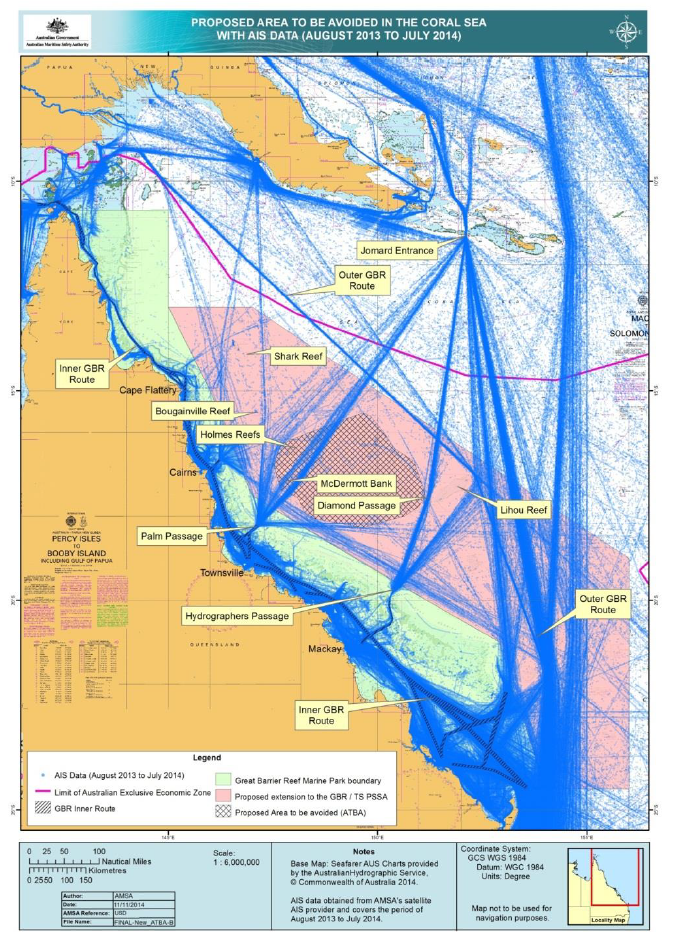
Figure 1: Location of the ATBA in the Coral Sea
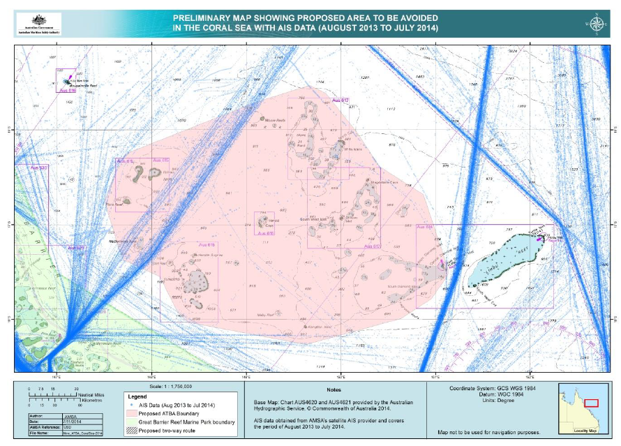
Figure 2: Extent of the ATBA
Geographical Coordinates of the Area to be Avoided in the Coral Sea
The geographical coordinates of the ATBA (figure 3) are provided below.
All geographical positions are based on WGS 84.
Individual coordinate numbers in brackets refer to those shown in figure 3.
Area to be avoided
An area to be avoided is established bounded by a line connecting the following
geographical positions:
| (1)
|
15° 42.48' S
|
149° 06.07' E
|
(11)
|
17° 59.43' S
|
150° 38.35' E
|
| (2)
|
15° 31.87' S
|
149° 40.07' E
|
(12)
|
18° 15.94' S
|
149° 37.97' E
|
| (3)
|
15° 36.90' S
|
149° 50.43' E
|
(13)
|
18° 01.91' S
|
148° 23.34' E
|
| (4)
|
16° 01.16' S
|
150° 09.79' E
|
(14)
|
17° 55.49' S
|
148° 16.26' E
|
| (5)
|
16° 23.25' S
|
150° 24.56' E
|
(15)
|
17° 32.90' S
|
148° 05.14' E
|
| (6)
|
16° 40.91' S
|
150° 52.21' E
|
(16)
|
17° 22.27' S
|
147° 41.63' E
|
| (7)
|
17° 28.26' S
|
151° 08.01' E
|
(17)
|
16° 45.01' S
|
147° 30.47' E
|
| (8)
|
17° 30.71' S
|
151° 08.01' E
|
(18)
|
16° 18.56' S
|
147° 40.61' E
|
| (9)
|
17° 32.59' S
|
151° 07.45' E
|
(19)
|
16° 15.00' S
|
147° 43.82' E
|
| (10)
|
17° 46.83' S
|
150° 57.56' E
|
|
|
|
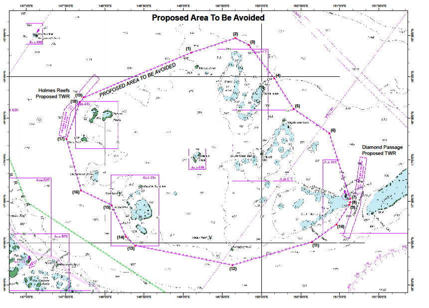
Figure 3: ATBA and two-way routes around it