SOLAS regulation IV/12.2 states that "Every ship, while at
sea, shall maintain a radio watch for broadcasts of maritime safety information on
the appropriate frequency or frequencies on which such information is broadcast for
the area in which the ship is navigating".
At the request of the IMO Sub-Committee on Radiocommunications (COM), the
NAVTEX Manual was first produced in 1988. Three subsequent editions have been
produced, with the fourth edition published in 2005 containing amendments endorsed
by the Maritime Safety Committee (MSC) at its seventy-eighth session in May 2004 by
MSC/Circ.1122.
At its seventh meeting in September 2005, the IHO Commission on the
Promulgation of Radio Navigational Warnings (CPRNW)footnote established a working group to review all World-Wide Navigational
Warning Service (WWNWS) documentation. The working group included representation
from the WMO and firstly prepared revisions to resolutions A.705(17), Promulgation
of Maritime Safety Information and A.706(17), World-Wide Navigational Warning
Service. The proposed revisions of these resolutions were circulated to IHO Member
States under IHB CL 104/2007, endorsed by the Sub-Committee on Radiocommunications
and Search and Rescue (COMSAR) at its twelfth session in April 2008 and subsequently
approved by the MSC at its eighty-fifth session in November/December 2008 by means
of MSC.1/Circ.1287 and MSC.1/Circ.1288, respectively.
The IHO CPRNW Working Group then prepared the revised Joint IMO/IHO/WMO
Manual on Maritime Safety Information incorporating the revised information from
resolutions A.705(17), as amended, and A.706(17), as amended. The revised text was
circulated to IHO Member States under cover of IHB CL 70/2008, endorsed by the
COMSAR Sub-Committee at its thirteenth session in January 2009 and subsequently
approved by the MSC at its eighty-sixth session in May/June 2009 by means of MSC.1/Circ.1310. The working group subsequently prepared the third
revision of the International SafetyNET Manual. The revised text of the
International SafetyNET Manual was circulated to IHO Member States under cover of
IHB CL 68/2009, endorsed by the COMSAR Sub-Committee at its fourteenth session in
March 2010 and approved by the MSC at its eighty-seventh session in May 2010 by
MSC.1/Circ.1364.
Continuing with the holistic approach of reviewing all maritime safety
information documents from the top-down, the working group prepared the fifth
revision of the NAVTEX Manual. The revised text of the NAVTEX Manual was circulated
to IHO Member States under cover of IHB CL 74/2010, endorsed by the COMSAR
Sub-Committee at its fifteenth session in March 2011 and subsequently approved by
the MSC at its eighty-ninth session in May 2011 by MSC.1/Circ.1403.
Following the review of all WWNWS documentation, an editorial review has
been conducted. As part of this editorial review, MSC.1/Circ.1287/Rev.1 and MSC.1/Circ.1288/Rev.1 were approved by the MSC at its ninety-second
session in June 2013, and MSC.1/Circ.1310/Rev.1 was approved by the MSC at its
ninety-fourth session in November 2014. Following the approval of these circulars,
the IHO WWNWS Sub-Committee Working Group reviewed the text of the NAVTEX Manual.
This sixth revision of the NAVTEX Manual was endorsed by the IHO and the WMO through
the WWNWS Sub-Committee, endorsed by the Sub-Committee on Navigation, Communications
and Search and Rescue (NCSR) at its third session in February/March 2016 and
subsequently approved by the MSC at its ninety-seventh session in November 2016 by
means of MSC.1/Circ.1403/Rev.1, with an entry into force date of 1 January 2018.
1 General information
1.1 NAVTEX is an international automated direct-printing service for
promulgation of Maritime Safety Information (MSI), navigational and meteorological
warnings, meteorological forecasts and other urgent safety-related messages to
ships. It was developed to provide a low-cost, simple and automated means of
receiving MSI on board ships at sea in coastal waters. The information transmitted
may be relevant to all sizes and types of vessel and the selective message-rejection
feature ensures that mariners can receive MSI broadcasts which are tailored to their
particular needs.
1.2 NAVTEX fulfils an integral role in the Global Maritime Distress and
Safety System (GMDSS) developed by the International Maritime Organization (IMO) and
incorporated into the 1988 amendments to the International Convention for the Safety
of Life at Sea (SOLAS), 1974, as amended, as a requirement for ships to
which the Convention applies.
1.3 This Manual describes the structure and operation of the NAVTEX
service. It is intended primarily for use by national Administrations and others
concerned with the preparation and broadcasting of MSI. It will also be of interest
to seafarers, shipowners and others who need to receive such information in order to
safely go about their business at sea. It should be used in conjunction with the
Joint IMO/IHO/WMO Manual on Maritime Safety Information (also published as the
IHO/IMO World-Wide Navigational Warning Service Guidance Document, IHO Publication
S-53).
2 NAVTEX service
2.1 Introduction
2.1.1 NAVTEX provides shipping with navigational and meteorological
warnings, meteorological forecasts and other urgent safety-related messages (as
listed in table 1, section 5) by automatic display or printout from a dedicated
receiver. It is suitable for use in all sizes and types of ships. Figure 1
illustrates the way the service is typically structured.

Figure 1 – Basic concept of the NAVTEX system
2.1.2 NAVTEX is a component of the IMO/IHO World-Wide Navigational
Warning Service (WWNWS) defined by resolutions A.706(17), as amended, and A.1051(27), as amended. It has also been included as an element of the
Global Maritime Distress and Safety System (GMDSS).
2.1.3 In the GMDSS, a NAVTEX receiving capability is part of the
mandatory equipment which is required to be carried in certain vessels under the
provisions of the International Convention for the Safety of Life at Sea (SOLAS), 1974, as amended.
2.1.4 Authority for coordinating the use of the frequencies 518 kHz, 490
kHz and 4209.5 kHz for NAVTEX services worldwide was delegated by ITU to IMO at
WRC-95 through resolution 339. This was reaffirmed at WRC-97. IMO has vested
responsibility for the overall management and coordination of the global NAVTEX
service to the NAVTEX Coordinating Panel. With respect to National NAVTEX broadcasts
on 490 kHz and 4209.5 kHz, the function of the NAVTEX Coordinating Panel is limited
to the allocation of transmission identification characters.footnote It should be noted that the provisions of the NAVTEX
Manual do not apply when planning a National NAVTEX service on other nationally
assigned frequencies. The Terms of Reference for this Panel are attached in annex 1.
2.1.5 Details of operational and planned NAVTEX services are published
periodically in the various national lists of radio signals, in an annex to the
International Telecommunication Union's (ITU) List IV – List of coast stations and
special service stations, and in the GMDSS Master Plan published by IMO in its
series of GMDSS Circulars.
2.2 Definitions
2.2.1 For the purposes of this Manual, the following definitions apply:
-
.1 Coastal warning means a navigational warning or in-force
bulletin promulgated as part of a numbered series by a National
Coordinator. Broadcast should be made by the International NAVTEX
service to defined NAVTEX service areas and/or by the International
SafetyNET service to coastal warning areas. (In addition,
Administrations may issue coastal warnings by other means).
-
.2 Coastal warning area means a unique and precisely defined sea
area within a NAVAREA/METAREA or Sub-area established by a coastal State
for the purpose of coordinating the broadcast of coastal maritime safety
information through the SafetyNET service.
-
.3 Global Maritime Distress and Safety System (GMDSS) means the
global communications service based upon automated systems, both
satellite and terrestrial, to provide distress alerting and promulgation
of maritime safety information for mariners.
-
.4 HF NBDP means High Frequency narrow-band direct-printing, using
radio telegraphy as defined in Recommendation ITU-R M.688.
-
.5 In-force bulletin means a list of serial numbers of those
NAVAREA, Sub-area or coastal warnings in force issued and broadcast by
the NAVAREA Coordinator, Sub-area Coordinator or National Coordinator.
-
.6 International NAVTEX service means the coordinated broadcast
and automatic reception on 518 kHz of maritime safety information by
means of narrow-band direct-printing telegraphy using the English
language.footnote
-
.7 International SafetyNET service means the coordinated broadcast
and automatic reception of maritime safety information via the Inmarsat
Enhanced Group Call (EGC) system, using the English language, in
accordance with the provisions of the International Convention for the
Safety of Life at Sea, 1974, as amended.
-
.8 Issuing Service means a National Meteorological Service which has
accepted responsibility for ensuring that meteorological warnings
and forecasts for shipping are disseminated through the
International SafetyNET service to the METAREA for which the Service
has accepted responsibility under the broadcast requirements of the
GMDSS..footnote
-
.9 Local warning means a navigational warning which covers inshore
waters, often within the limits of jurisdiction of a harbour or port
authority.
-
.10 Maritime safety information (MSI)footnote means navigational and meteorological
warnings, meteorological forecasts and other urgent safety-related
messages broadcast to ships.
-
.11 Maritime safety information service means the internationally
and nationally coordinated network of broadcasts containing information
which is necessary for safe navigation.
-
.12 METAREA means a geographical sea area* established for the
purpose of coordinating the broadcast of marine meteorological
information. The term METAREA followed by a roman numeral may be used to
identify a particular sea area. The delimitation of such areas is not
related to and shall not prejudice the delimitation of any boundaries
between States. (See figure 2).
*Which may include inland seas, lakes and waterways navigable by seagoing
ships.
-
.13 METAREA Coordinator
means the authority charged with coordinating marine meteorological
information broadcasts by one or more National Meteorological
Services acting as Preparation or Issuing Services within the
METAREA.
-
.14 Meteorological information means the marine meteorological
warning and forecast information in accordance with the provisions of
the International Convention for the Safety of Life at Sea, 1974, as
amended.
-
.15 National Coordinator means the national authority charged with
collating and issuing coastal warnings within a national area of
responsibility.
-
.16 National NAVTEX service means the broadcast and automatic
reception of maritime safety information by means of narrow-band
direct-printing telegraphy using frequencies other than 518 kHz and
languages as decided by the Administration concerned.
-
.17 National SafetyNET service means the broadcast and automatic
reception of maritime safety information via the Inmarsat EGC system,
using languages as decided by the Administration concerned.
-
.18 NAVAREA means a geographical sea area* established for the
purpose of coordinating the broadcast of navigational warnings. The term
NAVAREA followed by a roman numeral may be used to identify a particular
sea area. The delimitation of such areas is not related to and shall not
prejudice the delimitation of any boundaries between States. (See figure
3).
*Which may include inland seas, lakes and waterways navigable by seagoing
ships.
-
.19 NAVAREA Coordinator means the authority charged with
coordinating, collating and issuing NAVAREA warnings for a designated
NAVAREA.
-
.20 NAVAREA warning means a navigational warning or in-force
bulletin promulgated as part of a numbered series by a NAVAREA
Coordinator.
-
.21 Navigational warning means a message containing urgent
information relevant to safe navigation broadcast to ships in accordance
with the provisions of the International Convention for the Safety of
Life at Sea, 1974, as amended.
-
.22 NAVTEX means the system for the broadcast and automatic
reception of maritime safety information by means of narrow-band
direct-printing telegraphy.footnote
-
.23 NAVTEX Coordinator means the authority charged with operating
and managing one or more NAVTEX stations broadcasting maritime safety
information as part of the International NAVTEX service.
-
.24 NAVTEX coverage area means an area defined by an arc of a
circle having a radius from the transmitter calculated according to the
method and criteria given in resolution A.801(19), as amended, see annex
4.
-
.25 NAVTEX service area means a unique and precisely defined sea
area, wholly contained within the NAVTEX coverage area, for which
maritime safety information is provided from a particular NAVTEX
transmitter. It is normally defined by a line that takes full account of
local propagation conditions and the character and volume of information
and maritime traffic patterns in the region, as given in resolution
A.801(19), as amended, see annex 4.
-
.26 Other urgent safety-related information means maritime safety
information broadcast to ships that is not defined as a navigational
warning or meteorological information. This may include, but is not
limited to, significant malfunctions or changes to maritime
communications systems, and new or amended mandatory ship reporting
systems or maritime regulations affecting ships at sea.
-
.27 Rescue Coordination Centre (RCC) () means a unit responsible
for promoting efficient organization of search and rescue services and
for coordinating the conduct of search and rescue operations within a
search and rescue region. Note: The term RCC will be used within this
Manual to apply to either joint, aeronautical or maritime centres; JRCC,
ARCC or MRCC will be used as the context warrants.
-
.28 SafetyNET means the international service for the broadcast
and automatic reception of maritime safety information via the Inmarsat
EGC system. SafetyNET receiving capability is part of the mandatory
equipment which is required to be carried by certain ships in accordance
with the provisions of the International Convention for the Safety of
Life at Sea, 1974, as amended.
-
.29 SAR information means distress alert relays and other urgent
search and rescue information broadcast to ships.
-
.30 Sub-area means a subdivision of a NAVAREA/METAREA in which a
number of countries have established a coordinated system for the
promulgation of maritime safety information. The delimitation of such
areas is not related to and shall not prejudice the delimitation of any
boundaries between States.
-
.31 Sub-area Coordinator means the authority charged with
coordinating, collating and issuing Sub-area warnings for a designated
Sub-area.
-
.32 Sub-area warning means a navigational warning or in-force
bulletin promulgated as part of a numbered series by a Sub-area
Coordinator. Broadcast should be made by the International NAVTEX
service to defined NAVTEX service areas or by the International
SafetyNET service (through the appropriate NAVAREA Coordinator).
-
.33 UTC means Coordinated Universal Time which is equivalent to
GMT (or ZULU) as the international time standard.
-
.34 World-Wide Met-ocean Information and Warning Service
(WWMIWS)footnote means the internationally coordinated
service for the promulgation of meteorological warnings and forecasts.
-
.35 World-Wide Navigational Warning Service (WWNWS)footnote means the internationally and nationally
coordinated service for the promulgation of navigational warnings.
-
.36 In the operating procedures, coordination means that the
allocation of the time for data broadcast is centralized, the format and
criteria of data transmissions are compliant as described in the Joint
IMO/IHO/WMO Manual on Maritime Safety Information and that all services
are managed as set out in resolutions A.705(17), as amended, A.706(17),
as amended, and A.1051(27), as amended.
2.2.2 Delimitation of METAREAs
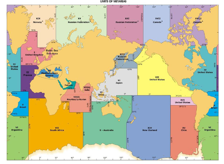
Figure 2 – METAREAs for coordinating and promulgating navigational
warnings under the World-Wide Navigational Warning Service
The delimitation of such areas is not related to and shall not prejudice the
delimitation of any boundaries between States.
2.2.3 Delimitation of NAVAREAs

Figure 3 – NAVAREAs for coordinating and promulgating meteorological
warnings and forecasts within the GMDSS
The delimitation of such areas is not related to and shall not prejudice the
delimitation of any boundaries between States.
3 General features of the NAVTEX system
3.1 The principal features are:
3.2 The operational and technical characteristics of the NAVTEX system
are contained in Recommendation ITU-R M.540-2footnote. Performance standards for shipborne equipment, if installed before
1 July 2005, are laid down in resolution A.525(13). If installed on or after 1 July 2005, they shall
conform to resolution MSC.148(77).footnote
4 Planning NAVTEX services
4.1 When planning NAVTEX services, Administrations should obtain
guidance at an early stage from IMO, through its NAVTEX Coordinating Panel. This may
be particularly important when installation of new stations and/or purchase of new
equipment is under consideration. Details of how to contact the Panel may be found
in annex 1.
4.2 International NAVTEX services on 518 kHz
When planning an International NAVTEX service it is essential to
appreciate the high level of national and international coordination required. The
central principles which should be borne in mind are as follows:
-
.1 All NAVTEX stations are part of the strategic infrastructure of both
the GMDSS and WWNWS.
-
.2 It is essential for the efficiency and effectiveness of the service
that a minimum number of stations are used. This may require national
Administrations to either share facilities or promulgate information
provided by Administrations of other nations.
-
.3 Each station contributes to the overall service in a coordinated way,
bearing in mind the geographical area covered by each station and the
effective coordination and control of information to be transmitted.
-
.4 The two basic areas which must be defined when establishing a NAVTEX
station are the NAVTEX coverage area and the NAVTEX service area. Each
station will provide all the information for a particular NAVTEX service
area. The boundaries of the NAVTEX service area must be wholly contained
within the coverage area, and must not overlap with adjacent NAVTEX
service areas (see figure 4).
-
.5 National Administrations seeking to establish NAVTEX services shall
undertake preliminary discussions with the NAVAREA Coordinator, METAREA
Coordinator and neighbouring Administrations prior to formal application
to IMO through the IMO NAVTEX Coordinating Panel. These discussions
shall consider the most appropriate NAVTEX service area boundaries,
possible geographical locations for transmitter sites to ensure optimal
coverage and links with Information Providers.
-
.6 The range of a NAVTEX transmitter depends on the
transmitted power and local radio propagation conditions. The actual
range achieved shall be adjusted to the minimum required for adequate
reception in the specified NAVTEX service area, taking into account the
needs of ships approaching from other areas. Experience indicates that
the required range of 250 to 400 nautical miles will normally be
attained by transmitted power of no more than 1 kW during daylight
with a 60% reduction during night conditions.
-
.7 After the choice of transmitter sites, the main need for
coordination lies in the assignment of B1 transmitter
identification characters (time schedules) and the agreement of proposed
NAVTEX service areas (if appropriate). Preliminary discussions between
national Administrations seeking to establish or amend NAVTEX services
and neighbouring Administrations shall be coordinated by the NAVAREA
Coordinator prior to formal application for a B1 transmitter
identification character. Throughout the process the IMO NAVTEX
Coordinating Panel is available to advise and liaise on the final limits
of NAVTEX service areas if these cannot be agreed locally.
-
.8 The IMO NAVTEX Coordinating Panel will only allocate
B1 transmitter identification characters after the NAVTEX
service areas have been agreed.
-
.9 Once a NAVTEX transmitter has been declared operational, if a national
Administration wishes to:
-
.9.1 move the transmitter site; and/or
-
.9.2 amend the limits of its NAVTEX service area,
-
then the whole coordination process outlined above must be
repeated, keeping the NAVTEX Coordinating Panel informed at
all times.
-
.10 A National NAVTEX Coordinator shall be established to oversee the
operation of the NAVTEX services established by each national
Administration. The responsibilities of the NAVTEX Coordinator are
defined in section 12 of this Manual.

Figure 4 – Example of NAVTEX service areas
The Baltic Sea and its approaches have been divided into five individual
NAVTEX service areas. Within each service area, maritime safety information is
provided from a separate NAVTEX station which has been allocated a dedicated
B1 transmitter identification character. It is a fundamental
requirement that the range of each NAVTEX transmitter is sufficient to include the
whole of the NAVTEX service area assigned to its B1 transmitter
identification character.
4.3 National NAVTEX services on 490 kHz or 4209.5 kHz
The provisions of the NAVTEX Manual apply to National NAVTEX services on
490 kHz or 4209.5 kHz. When planning a National NAVTEX service, the IMO NAVTEX
Coordinating Panel is responsible for the allocation of B1 transmitter
identification characters; however, the establishment of NAVTEX service areas and
the compulsory use of the English language are not required.
4.4 National NAVTEX services on other frequencies
The provisions of the NAVTEX Manual do not apply when planning a National
NAVTEX service on nationally assigned frequencies.
5 NAVTEX message technical
characters
5.1 Overview of technical characters, B1, B2,
B3, B4
5.1.1 NAVTEX messages include instructions to the NAVTEX receiver for
processing maritime safety information in the form of the NAVTEX message identity,
which consists of four technical "B" characters which make up an alphanumeric code.
In order for messages to be correctly processed, they must consist of data
conforming to these "B" characters:
-
B1 Transmitter identification character
-
B2 Subject indicator character
-
B3B4 Message numbering characters
5.2 B1 – Transmitter identification character
5.2.1 The transmitter identification character (B1) is a
single letter which is allocated to each transmitter. It is used to identify the
broadcasts which are to be accepted by the receiver and those to be rejected, and
also the time slot for the transmission.
5.2.2 In order to avoid erroneous reception and interference of
transmissions from two stations having the same transmitter identification
character, it is necessary to ensure that such stations have a large geographical
separation. Allocation of transmitter identification characters by alphabetical
sequence to adjacent sites can also cause problems; hence, consecutive transmitter
identification characters are not normally allocated to adjacent stations.
Experience has shown that this removes the risk of a station which over-runs its
time slot masking the phasing signal of an adjacent station which is about to begin
its transmission.
Table 1 – Technical "B" characters which make up the
full NAVTEX message identityfootnote, footnote
| B1
Transmitter identification
character
|
B2
Subject indicator character
|
B3 B4
Message numbering characters
|
| 1 letter
|
1 letter
|
2 digits
|
| A to X
|
A = Navigational warnings
|
01 to 99 (message numbering characters "00" are not
to be used for routine messages)
|
| B = Meteorological
warnings
|
| C = Ice reports
|
| D = Search and rescue
information, acts of piracy warnings, tsunamis and other natural
phenomena
|
| E = Meteorological
forecasts
|
| F = Pilot and VTS service
messages
|
| G = AIS service messages
(non-navigational aid)
|
| H = LORAN messages
|
| I = Currently not used
|
| J = GNSS messages regarding PRN
status
|
| K = Other electronic
navigational aid system messages
|
| L = Other navigational
warnings – additional to B2 character
A16
|
| M
=
|
|
|
| N
=
O =
P =
Q
=
R =
|

|
Currently not used
|
| S
=
|
|
|
| T
=
|
|
|
| U
=
|
|
|
| V
=
|
|
|
| W=
X =
Y =
|

|
Special services allocation by the IMO NAVTEX Coordinating
Panel
|
| Z = No message on
hand
|

Figure 5 – Example of NAVTEX receiver with LCD screen
5.2.3 NAVTEX transmissions have a designed maximum range of about 400
nautical miles. The minimum distance between two transmitters with the same
transmitter identification identifier must, therefore, be sufficient to ensure that
a receiver cannot be within range of both at the same time.
5.2.4 Close coordination between transmitting stations in adjacent
NAVAREAs/METAREAs is necessary to achieve this separation. For this reason, national
Administrations shall request the advice of the IMO NAVTEX Coordinating Panel at an
early stage in the planning of a new NAVTEX service. The Panel will allocate
B1 transmitter identification characters in such a way as to minimize
the risk of interference occurring.
5.2.5 Table 2 shows the transmitter identification characters and their
associated transmission start times used by the IMO NAVTEX Coordinating Panel to
evaluate and allocate transmitter identification characters A to X, regardless of
the geographical position of the station anywhere in the world. Each transmitter
identification character is allocated a maximum transmission time of 10 minutes
every 4 hours. Because the NAVTEX system always utilizes a single frequency, it
is fundamental to its successful operation that the following time slots are
strictly adhered to, and that broadcasts do not overrun their allotted 10
minutes.
Table 2 – NAVTEX transmission start times
| Transmitter identification character
(B1)
|
Transmission start times
(UTC
|
| A
|
0000
|
0400
|
0800
|
1200
|
1600
|
2000
|
| B
|
0010
|
0410
|
0810
|
1210
|
1610
|
2010
|
| C
|
0020
|
0420
|
0820
|
1220
|
1620
|
2020
|
| D
|
0030
|
0430
|
0830
|
1230
|
1630
|
2030
|
| E
|
0040
|
0440
|
0840
|
1240
|
1640
|
2040
|
| F
|
0050
|
0450
|
0850
|
1250
|
1650
|
2050
|
| G
|
0100
|
0500
|
0900
|
1300
|
1700
|
2100
|
| H
|
0110
|
0510
|
0910
|
1310
|
1710
|
2110
|
| I
|
0120
|
0520
|
0920
|
1320
|
1720
|
210
|
| J
|
0130
|
0530
|
0930
|
1330
|
1730
|
2130
|
| K
|
0140
|
0540
|
0940
|
1340
|
1740
|
2140
|
| L
|
0150
|
0550
|
0950
|
1350
|
1750
|
2150
|
| M
|
0200
|
0600
|
1000
|
1400
|
1800
|
2200
|
| N
|
0210
|
0610
|
1010
|
1410
|
1810
|
2210
|
| O
|
0220
|
0620
|
1020
|
1420
|
1820
|
2220
|
| P
|
0230
|
0630
|
1030
|
1430
|
1830
|
2230
|
| Q
|
0240
|
0640
|
1040
|
1440
|
1840
|
2240
|
| R
|
0250
|
0650
|
1050
|
1450
|
1850
|
2250
|
| S
|
0300
|
700
|
1100
|
1500
|
1900
|
2300
|
| T
|
0310
|
0710
|
1110
|
1510
|
1910
|
2310
|
| U
|
0320
|
0720
|
1120
|
1520
|
1920
|
2320
|
| V
|
0330
|
0730
|
1130
|
1530
|
1930
|
2330
|
| W
|
0340
|
0740
|
1140
|
1540
|
1940
|
2240
|
| X
|
0350
|
0750
|
1150
|
1550
|
1950
|
2250
|
5.2.6 In some regions, it has become necessary to accommodate a large
number of stations. In extreme cases, it has even been necessary to reuse some
transmitter identification characters for a second time within a region. Where this
occurs every effort is made to ensure stations with the same character are as far
apart as possible to reduce the risk of mutual interference.
5.3 B2 – Subject indicator character
5.3.1 Information is grouped by subject in the NAVTEX broadcast and each
subject group is allocated a B2 subject indicator character.
5.3.2 The subject indicator character is used by the receiver to identify
the different classes of messages as listed in table 1.
5.3.3 Some subject indicator characters can be used to reject messages
concerning certain subjects which may not be required by the ship (e.g. Ice report
messages may be rejected by deselecting the B2 subject indicator
character C on the NAVTEX receiver on board a ship.).
5.3.4 Reception of messages, transmitted using subject indicator
characters A, B, D and L, which have been allocated for navigational warnings,
meteorological warnings, search and rescue information, acts of piracy warnings,
tsunamis and other natural phenomena, is mandatory and cannot be deselected on the
NAVTEX receiver. This has been designed to ensure that ships using NAVTEX always
receive the most essential information.
5.3.5 It is not possible to transmit or receive two NAVTEX messages with
the same NAVTEX message identity (made up of the four technical characters).
Therefore the B2 subject indicator character L has been designated for
use in the unlikely event that a NAVTEX Coordinator has more than 99 navigational
warning messages in force and requiring transmission at the same time, all using
B2 subject indicator character A, with the same B1
transmitter identification character.
5.3.6 Messages received which have been transmitted using subject
indicator character D will set off an alarm built into the NAVTEX receiver.
5.3.7 In the International NAVTEX service, Administrations shall obtain
the agreement of the IMO NAVTEX Coordinating Panel for all proposals for the use of
special service subject indicator characters. Such proposals shall meet the
following criteria:
-
.1 The full international service must remain unaffected.
-
.2 The special service broadcasts shall be transmitted only
when time allows, and with due regard to the necessity for the frequency
to remain unused for a high percentage of the time.
-
.3 The special service broadcast shall only be used for its
approved purpose.
5.4 B3B4 – Message numbering characters (NAVTEX
number)
5.4.1 Each message within each subject group is allocated a two digit
sequential serial number beginning at 01 and ending at 99. The
B3B4 message numbering characters together, are often
referred to as the "NAVTEX number".
5.4.2 The NAVTEX number is solely allocated as a component of the NAVTEX
message identity and should not be confused with (and bears no correlation to), the
series identity and consecutive number of the NAVAREA or Coastal warning contained
in the message.
5.4.3 Messages broadcast using NAVTEX number B3B4 =
00 cannot be rejected and will automatically override any selection of B1
transmitter identification characters as well as any B2 subject indicator
characters selected on the NAVTEX receiver.
5.4.4 Use of NAVTEX number B3B4 = 00 must therefore
be strictly controlled, since messages carrying it will always be printed or
displayed every time they are received. Routine messages and service messages must
never be allocated B3B4 = 00. The correct use of B2
characters A, B, D and L, will ensure that messages containing safety information
will always be printed or displayed on first receipt.
6 Message identity
6.1 The individual NAVTEX message identity is the amalgamation of all
four technical characters B1B2B3B4
(transmitter identification character/subject indicator character/message numbering
characters).
6.2 When a message is received for the first time by a NAVTEX receiver,
the message identity is recorded and stored in the memory for 72 hours. This ensures
that subsequent transmissions of the same message are not re-printed or repeated in
the display, unless they are re-received over 72 hours later. In the unlikely event
that all 99 NAVTEX numbers for a particular subject group, from a particular
transmitter, are in use at the same time, or have been allocated within the past 72
hours, an alternative B2 character must be utilized; for example,
B2 = L has been set aside to be used for additional navigational
warnings if all 99 NAVTEX numbers for subject group B2 = A are in use.
6.3 Each NAVTEX message identity shall be allocated by the relevant
NAVTEX Coordinator, who is the authority responsible for the selection of
information to be broadcast by each transmitter within each subject group. A single
NAVTEX Coordinator may have more than one transmitter under their control. Specific
advice on the use of alternative B2 subject indicator characters as
mentioned in 6.2 above, can be provided by the IMO NAVTEX Coordinating Panel.
7 Message format
7.1 NAVTEX messages must be composed in accordance with the guidelines
contained in the Joint IMO/IHO/WMO Manual on Maritime Safety Information and
IHO Publication S-53. The format of all messages must be in strict accordance with
figure 6. This defines the essential elements of the messages which influence the
operation of the receiver. Great care is required to avoid errors of syntax in the
groups ZCZC B1B2B3B4 and NNNN as they
will cause receivers to operate incorrectly, and may well result in messages not
being received.
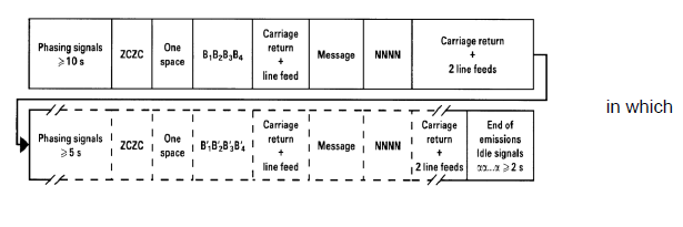
Figure 6 – Standard format for NAVTEX messages
7.2 The phasing signal is automatically transmitted by the NAVTEX
transmitter at the beginning of each message and is critical to the effective
operation of the system. It is this signal which enables a receiver to lock on to a
particular station's transmission, providing the frequency is not already in use.
7.3 If another station within transmitting range and with a time slot
prior to the station selected overruns its time slot (regardless of the
B1 transmitter identification character in use), its transmission
will blank the phasing signal of the subsequent transmitter. It will then seem to
the receiver as if the second station is off the air and its broadcast will not be
received, possibly denying the user significant safety information. This is the
primary reason behind the importance of each station adhering to its allocated time
slots. Similarly if the phasing signal for a particular station is too short, some
receivers will be unable to lock on to the transmission.
7.4 Basic message elements
Table 3 – Basic message elements
| Element
|
Example
|
| Phasing signal
|
|
| Start of message group
|
ZCZC
|
| One space
|
|
| NAVTEX message identity
|
FA01
|
| Carriage return + line feed
|
|
| Message content
|
(Date Time Group – Optional
e.g. 040735 UTC OCT 17)
NAV I 114/17
ENGLISH
CHANNEL. START POINT SOUTHWARD.
CHART BA 442
(INT 1701).
UNEXPLODED ORDNANCE LOCATED
49-51.97N 003-39.54W AND
49-55.24N 003-40.79W.
|
| End of message instruction
|
NNNN
|
| Carriage return + two line feeds
|
|
| Phasing signal
|
|
7.5 When a message has been received error-free, a record is made by the
receiver of the NAVTEX message identity. This unique identifier is used to suppress
the printing or display of repeated transmissions of the same message.
7.6 On National NAVTEX services it is important to keep to the same basic
message format as that required for the International NAVTEX service. It is also
important to ensure that the full broadcast does not overrun the allocated time
slot. However, in order to meet national requirements, message content may deviate
from the guidelines provided for the International NAVTEX Service if required.
7.7 Examples of navigational warning messages
Note: Further examples are available for consultation in the
Joint IMO/IHO/WMO Manual on Maritime Safety Information.
7.8 Examples of meteorological messages
Note: Further examples are available for consultation in the
Joint IMO/IHO/WMO Manual on Maritime Safety Information.
8 Language and national broadcast options
8.1 International NAVTEX Service messages on 518 kHz shall be broadcast
only in English in accordance with resolutions A.706(17), as amended, and A.1051(27), as amended
8.2 There is often a requirement for NAVTEX broadcasts to be made in
national languages in addition to English. This shall only be achieved by
the provision of a National NAVTEX service. National NAVTEX services use frequencies
other than 518 kHz, and languages as decided by the Administrations concerned. These
National NAVTEX services may be broadcast on 490 kHz or 4209.5 kHz, or on an
alternative nationally assigned frequency.
9 Information control
9.1 The time-shared nature of NAVTEX services imposes the need for strict
discipline in controlling the information flow of the broadcast. To achieve this, it
is necessary to coordinate the messages in each B2 category at each
transmitter. In general, all messages shall be brief and clear and avoid
duplication. Strict adherence to relevant guidelines in resolutions A.706(17), as
amended, A.1051(27), as amended, and the Joint
IMO/IHO/WMO Manual on Maritime Safety Information is recommended.
9.2 In addition, certain operating procedures have also been found
necessary:
-
.1 messages in each category should be broadcast in reverse order of
receipt by the NAVTEX Coordinator, with the latest being broadcast
first; and
-
.2 cancellation messages should be broadcast once only. The cancelled
message should not be transmitted on the broadcast in which its
cancellation message appears.
10 Message content
10.1 It is important that national Administrations operating or planning
NAVTEX services are clear about what sort of information should be included in the
messages.
10.2 The International NAVTEX service should be used for transmitting
maritime safety information only and should not be used as a medium for
providing Notices to Mariners or for broadcasting Local Warnings. NAVTEX is
essentially a medium for broadcasting information that is needed by ships to
safely navigate through the NAVTEX service area of the appropriate NAVTEX station,
particularly those ships on coastal passages. More detailed guidance in respect to
different classes of messages is given below. Examples of the content and layout of
NAVTEX messages are shown in the Joint IMO/IHO/WMO Manual on Maritime Safety
Information. This publication should be available to all personnel
responsible for the drafting of messages to be broadcast by NAVTEX stations.
10.2.1 Navigational warnings
-
.1 coastal warnings and NAVAREA warnings (B2 = A
or L) issued under the guidance of resolution A.706(17), as amended,
which would be of concern to ships in the NAVTEX service area allocated
to the transmitter should be included in the broadcast. Relevant coastal
warnings should normally be repeated at every scheduled transmission for
as long as they remain in force; however, if they are readily available
to mariners by other official means, for example in Notices to Mariners,
then after a period of six weeks they may no longer be broadcast. NAVTEX
Coordinators should arrange to receive NAVAREA warnings appropriate to
their area for inclusion in their broadcasts. These should be broadcast
at least twice each day – to avoid overloading the broadcast time slot,
they should normally be scheduled for transmission during slots that do
not include weather forecasts (see 12.4);
-
.2 in-force bulletins (a summary of navigational warnings in force)
should normally be broadcast each week; and
-
.3 local warnings should not be broadcast on International NAVTEX, i.e.
information relating to inshore waters, often within the limits of
jurisdiction of a harbour or port authority.
10.2.2 Meteorological warnings and forecasts
-
.1 meteorological warnings (B2 = B), e.g. gale
warnings, should be allocated a priority of IMPORTANT (see section 11)
and be repeated at subsequent scheduled transmissions for as long as the
warning is in force. These messages should contain only the appropriate
warnings and should be separate from the weather forecasts;
-
.2 weather forecasts (B2 = E) should be broadcast
at least twice each day. This service should be carefully coordinated
where transmitters are geographically close together;
-
.3 routine ice reports are normally broadcast on NAVTEX once a day; and
-
.4 ice accretion warnings (icing warnings) are normally included in gale
warnings. If no gale warning is issued, they are to be treated as a
meteorological warning (see 10.2.2.1).
10.2.3 Search and rescue information
-
.1 the NAVTEX broadcast is not suitable for distress
traffic. Therefore, only the initial distress message should be
retransmitted on NAVTEX, using B2 = D, in order to alert
mariners to a distress situation, by setting off an audio alarm.
-
.2 a single authority, which will normally be a Rescue Coordination
Centre (RCC), should be designated SAR Coordinator to input information
via the NAVTEX Coordinator, for a NAVTEX message. The initial
shore-to-ship distress-related message should have previously been
broadcast on the appropriate distress frequency prior to any related
NAVTEX message being broadcast.
10.2.4 Piracy warnings
Piracy warnings should be transmitted using B2 = D, in order
to alert mariners by setting off an audio alarm. They should be broadcast
immediately on receipt and at subsequent scheduled transmissions.
10.2.5 Tsunamis and other natural phenomena warnings
Tsunami, negative tidal surge warnings should be transmitted using
B2 = D, in order to alert mariners by setting off an audio alarm.
They should be broadcast immediately on receipt and at subsequent scheduled
transmissions.
10.2.6 Pilot and VTS service messages
Technical subject indicator character, B2 = F, is only to be
used for broadcasting temporary alterations, movement or suspension to pilot or VTS
services. This category is for the information of all ships and is not to be used
for specific instructions to individual ships or pilots.
10.2.7 No messages on hand
When there are no NAVTEX messages to be disseminated at a scheduled
broadcast time, a brief message should be transmitted to advise the mariner that
there is no message traffic on hand. Technical subject indicator character,
B2 = Z, is to be used to announce "NO MESSAGES ON HAND".
10.2.8 Use of abbreviations
Common examples of abbreviations used in the International NAVTEX service
are contained in the Joint IMO/IHO/WMO Manual on Maritime Safety Information.
10.2.9 National NAVTEX services
Transmissions on 490 kHz or 4209.5 kHz may simply repeat the messages
broadcast over the International NAVTEX service but in a national language, or they
may be tailored to meet particular national requirements, for example by providing
different or additional information to that broadcast on the International NAVTEX
service, targeted at recreational vessels or fishing fleets.
11 Message priorities and broadcast procedures in the International NAVTEX
service
11.1 Message priorities
11.1.1 The message originator is responsible for assessing the urgency of
the information and inserting the appropriate priority marking. One of three message
priorities is used to dictate the timing of the first broadcast of a new warning in
the NAVTEX service. In descending order of urgency, they are:
-
VITAL
- for immediate broadcast, subject to avoiding
interference to ongoing transmissions. Such messages should also
be passed to the appropriate NAVAREA Coordinator for possible
transmission as a NAVAREA warning via SafetyNET;
-
IMPORTANT
- for broadcast at the next available period
when the frequency is unused; and
-
ROUTINE
- for broadcast at the next scheduled
transmission.
11.1.2 Both VITAL and IMPORTANT messages should be repeated at each
scheduled transmission time slot, if the situation is still valid.
11.1.3 The message priority is a procedural instruction for the NAVTEX
Coordinator or the transmitting station and should not be included in the
message. By selecting the appropriate priority of VITAL, IMPORTANT or ROUTINE at the
transmission terminal, the message will be broadcast with the correct priority.
11.1.4 In order to avoid unnecessary disruption to the service, the
priority marking VITAL is to be used only in cases of extreme
urgency, i.e. to relay an initial shore-to-ship distress-related message or
acts of piracy warnings, tsunamis and other natural phenomena warnings. In addition,
VITAL messages are to be kept as brief as possible and in accordance with the
Joint IMO/IHO/WMO Manual on Maritime Safety Information. The information
provider is responsible for ensuring that the NAVTEX Coordinator is fully and
immediately aware when a message should be broadcast with the priority of VITAL.
11.1.5 VITAL messages will normally be broadcast using NAVTEX number
B3B4 = 00.
11.2 Broadcast procedures
-
.1 VITAL
-
priority messages Messages assessed as VITAL are to be
broadcast immediately, subject to avoiding interference to
ongoing transmissions. On receipt of a message with a VITAL
priority, the NAVTEX Coordinator will commence monitoring
the NAVTEX frequency. If the frequency is clear, the VITAL
message is to be transmitted immediately. If the frequency
is in use, the Coordinator should contact the station which,
according to the schedule, will be transmitting during the
following time slot and ask it to postpone their
transmission start by one minute, to allow a space for the
VITAL message. Once the VITAL message has been transmitted,
the scheduled station is free to start its routine
transmissions;
-
-
.3 ROUTINE
-
priority messages Messages assessed as ROUTINE, are to be
broadcast at the next scheduled transmission time. This
level of priority will be appropriate for almost all
messages broadcast on NAVTEX and is always to be used unless
special circumstances dictate the use of the procedures for
an IMPORTANT or VITAL priority message.
11.3 Meteorological NAVTEX messages
The following priorities are to be assigned to meteorological NAVTEX
messages:
-
.1 Tsunami warnings = VITAL
-
.2 Meteorological warnings = IMPORTANT
-
.3 Meteorological forecasts = ROUTINE
-
.4 For other natural phenomena warnings, either VITAL or IMPORTANT may be
used.
11.4 National NAVTEX services
The broadcast procedures concerning differing message priorities are the
same for both the International and National NAVTEX services.
12 Responsibilities of a NAVTEX Coordinator
12.1 The NAVTEX Coordinator is responsible for the messages transmitted
by each station under their control. This responsibility includes checking that the
content of each message is in accordance with the Joint IMO/IHO/WMO Manual on
Maritime Safety Information and also, that it is relevant to the NAVTEX
service area of the transmitting station. Thus a user may choose to accept messages,
as appropriate, either from the single transmitter which serves the sea area around
their position or from a number of transmitters. Ideally, the user should select the
station within whose coverage area their vessel is currently operating and the
station into whose coverage area their vessel will transit next.
12.2 The NAVTEX Coordinator must:
-
.1 act as the central point of contact on matters relating to NAVTEX
transmissions for a given transmitter or number of transmitters;
-
.2 be responsible for continuously ensuring quality control for the
operation of the NAVTEX transmitting stations under its jurisdiction.
This should be achieved with the cooperation of the information
providers to ensure that:
-
.2.1 messages are always concise and can be transmitted within
the designated 10-minute time slots assigned by the IMO NAVTEX
Coordinating Panel;
-
.2.2 MINIMUM power is used to achieve satisfactory range
performance; and
-
.2.3 the coordinated service is operating satisfactorily;
.3 assess all requests for NAVTEX messages immediately upon receipt;
-
.4 schedule each message for broadcast in accordance with the priority of
VITAL, IMPORTANT or ROUTINE;
-
.5 monitor the International NAVTEX frequency along with any other
National frequency used by the transmitters under their jurisdiction in
order to ensure that the messages have been correctly broadcast;
-
.6 monitor the International NAVTEX frequency along with any other
National frequency used in order to identify vacant transmission periods
required for VITAL or IMPORTANT messages;
-
.7 pass all information which warrants promulgation outside of their
NAVTEX service area directly to the appropriate authority, using the
quickest possible means;
-
.8 allocate a message identity to each message, including the sequential
NAVTEX number;
-
.9 ensure that NAVTEX messages which have been cancelled are removed from
the broadcast schedule at the same time as the cancellation message is
promulgated;
-
.10 broadcast in-force bulletins not less than once per week at a regular
scheduled time;
-
.11 promote and oversee the use of established international standards
and practices with respect to the format and protocols associated with
NAVTEX messages;
-
.12 maintain records of source data relating to NAVTEX messages in
accordance with the requirement of the national Administration;
-
.13 be aware of the responsibilities of a NAVAREA, Sub-area and National
Coordinator contained in resolution A.706(17), as amended, paying
particular attention to the specific guidance for the promulgation of
internationally coordinated maritime safety information provided
therein;
-
.14 be aware of the responsibilities of a METAREA Coordinator
contained in resolution A.1051(27), paying particular
attention to the specific guidance for the promulgation of
internationally coordinated maritime safety information provided
therein; and
-
.15 take into account the need for contingency planning.
12.3 Management of the service
Data priority:
Most information broadcast on NAVTEX services relates to either
navigational warnings or meteorological information. These types of information
often originate from different organizations within a country and it is not until
they arrive with the NAVTEX Coordinator that an assessment can be made as to whether
there is too much information for the relevant broadcast time slot. Each data
provider may consider their data to be more important and therefore, require
transmission in full. However, the NAVTEX Coordinator needs to control the overall
volume of data broadcast and may need to refer back to data providers to prioritize
their information and reduce the amount of data to be broadcast. Some NAVTEX
Coordinators utilize digital systems which include software that provides a readout
of predicted transmission times for data held ready for broadcast. This enables the
Coordinator to anticipate any problems and take action before the scheduled
broadcast.
Data to meet purely national requirements should not be broadcast on the
International NAVTEX service, but should be migrated to a National NAVTEX service
(see section 14).
12.4 Balancing the volume of data to be broadcast throughout the daily
transmission cycle
12.4.1 For many categories of messages there is no option with regard to
when they should be transmitted. However, in order to minimize the risk of
over-running the allocated 10-minute time slot, it is possible to balance the
overall length of transmissions by broadcasting NAVAREA warnings at different times
from weather forecasts and the in-force bulletin. An example of how this may be
managed is given below for a station with a B1 transmitter identification
character C:
| Time
slot
|
Content
|
| 0020-0030
|
coastal warnings
NAVAREA warnings
|
| 0420-0430
|
coastal warnings
in-force
bulletin
|
| 0820-0830
|
coastal warnings
weather
forecasts
|
| 1220-1230
|
coastal warnings
NAVAREA warnings
|
| 1620-1630
|
coastal warnings
ice reports
|
| 2020-2030
|
coastal warnings
weather
forecasts
|
13 Best practice for those using the service
13.1 In order to ensure that all necessary maritime safety information
has been received, it is recommended that the NAVTEX receiver is switched on at
least 12 hours before sailing, or preferably left on at all times.
13.2 Logging
13.2.1 The reception of navigational warnings or meteorological
information on NAVTEX does not need to be noted in the radio log; the NAVTEX
printout (or the non-volatile message memory) satisfies the requirements of regulation 17 of chapter IV of the 1974 SOLAS Convention,
as amended.
14 Mutual interference between NAVTEX stations
14.1 The two principal causes of interference are:
14.2 Although NAVTEX continues to be generally reliable and an effective
medium for the promulgation of maritime safety information, the worldwide
infrastructure continues to expand and the volume of information that each
Administration disseminates through the International NAVTEX service continues to
increase. There is a danger that in some geographical areas, without firm
management, both the system and system users may become overloaded with information
on the single frequency used. This is of particular importance when handling
messages of VITAL priority.
14.3 Many stations are filling their allotted 10-minute time slots and an
increasing number are over-running. Instances of interference with neighbouring
stations, as a result of over-running the time allocation, are also increasing.
Where adjacent stations have transmitter identification characters which follow
alphabetically (i.e. adjacent time slots), if the first station over-runs, it may
mask the phasing signal of the second station such that, to the user, it seems as if
the second station is off the air. Maritime safety information from the second
station, although broadcast, may not be received by the system users. Over-run is
usually caused by one or more of the following which must be avoided preferably by
controlling the volume of data broadcast:
-
.1 a significant increase in safety-critical activity such as cable
laying. Navigational warnings promulgating such activity often include
numerous waypoints which are listed by Latitude and Longitude;
-
.2 meteorological information provided in a manner which is
not concise and easily assimilated by the system user or for a much
wider area than is covered by the NAVTEX station; and
-
.3 additional information provided for non-SOLAS system
users, e.g. longer-range weather forecasts for fishing and recreational
vessels.
See also section 7.3.
14.4 As the GMDSS spreads to non-SOLAS mariners, their requirements for
information are often different from the SOLAS ships and may be determined at a
national level. SOLAS ships trading internationally usually pass through the area of
coverage of a NAVTEX transmitter in a day; for them a 24-hour weather forecast
usually suffices. However, fishing vessels and recreational vessels often remain in
the same vicinity for several days and may require much longer-range forecasts which
take up more transmission time.
14.5 In order to keep the quantity of information that is broadcast on
518 kHz to manageable levels and to reduce avoidable interference on this frequency,
Administrations must:
-
.1 monitor the volume of data broadcast and, together with adjacent
Administrations, actively manage the system to ensure that interference
caused by over-running allocated time slots is eliminated; and
-
.2 transmit non-English language broadcasts for SOLAS vessels and
broadcasts of information provided specifically for non-SOLAS vessels on
490 kHz or 4209.5 kHz as required. B1 characters for these
frequencies will be allocated by the IMO NAVTEX Coordinating Panel, on
request.
14.6 Excessive power output also causes interference between stations
with the same B1 transmitter identification character/time slot, but
located in different regions. This has particularly been identified at night, as the
number of operational NAVTEX stations increases. Occasionally, this can be caused by
atmospheric conditions, but is generally caused by excessive power output from one
of the stations. It is recommended that Administrations restrict the power output
from their transmitters to that required to cover the designated NAVTEX service
area, particularly at night, in order to avoid interference. Experience indicates
that the required range of 250 to 400 nautical miles will normally be attained by
transmitted power of no more than 1 kW during daylight with a 60% reduction
during night conditions.
14.7 When interference is detected, particularly when it affects the
service to system users, the matter should be addressed immediately. When the
interference is with adjacent stations, attempts should be made to resolve the
problem locally. Advice may also be sought from the NAVAREA Coordinator. In
addition, the IMO NAVTEX Coordinating Panel should be alerted to the problem. When
the interference is from a station with the same B1 character in a
different area, the NAVTEX Coordinating Panel must be contacted and they will
initiate any necessary investigation/action.
15 Notification of NAVTEX services
15.1 National Administrations should ensure that mariners are informed of
the establishment of, and/or changes to, NAVTEX services by inclusion of full
details in Notices to Mariners and lists of radio signals. In addition, full details
should be forwarded to the appropriate NAVAREA Coordinator, METAREA Coordinator and:
International Maritime Organization
4 Albert
Embankment London SE1 7SR
United Kingdom
Telephone: +44 (0)20 7735 7611
Telefax: +44 (0)20 7587 3210
Email:
ncsr@imo.org (in subject line add: for Chair, IMO NAVTEX
Coordinating Panel)
|
International Telecommunication Union
Radio
communication Bureau
Place des
Nations
1211 Genève 20
Switzerland
Telephone: +41 22 7305560
Telefax:
+41 22 7305785
E-mail: brmail@itu.int
|